When I got back to town stopped and took this pick. There are 3 of these RR bridges in town. They are 1 block apart from each other. The Southern most one is 3 blocks North of my house. The tracks were across the street from me. Built in 1855 and used 130 years. All 3 are still in very good shape. I don't remember ever seeing any repairs done to them. I guess they were built well.


-
Enjoy XS650.com? Consider making a donation to help support the site.
XS650.com receives a small share of sales from some links on this page, but direct donations have a much greater impact on keeping this site going.
You are using an out of date browser. It may not display this or other websites correctly.
You should upgrade or use an alternative browser.
You should upgrade or use an alternative browser.
Just Ride.
- Thread starter Jim
- Start date
When I got back to town stopped and took this pick. There are 3 of these RR bridges in town. They are 1 block apart from each other. The Southern most one is 3 blocks North of my house. The tracks were across the street from me. Built in 1855 and used 130 years. All 3 are still in very good shape. I don't remember ever seeing any repairs done to them. I guess they were built well.
View attachment 172073
View attachment 172074
That’s very cool! The history that is all around us.

All 3 are still in very good shape. I don't remember ever seeing any repairs done to them. I guess they were built well.
That is a very pretty bridge indeed Greg! It sure looks to be stoutly built. Sometimes the most interesting things are right in our own hometowns.
The whole subject of bridges is very interesting and a civil engineering prof named Dr. Henry Petroski at Duke (I think) University has done some great work on the idea that:
- most first designs of a bridge (or nearly anything else for that matter) fail;
- the second versions are waaaayyy over-built to prevent ANY failures;
- as confidence is gained and advances in analysis come about, subsequent designs are increasingly less conservative until another failure occurs;
- the cycle repeats (and that is how technological progress is made).
JAX71224
jax71224
Sure would like a pros7hesis like his!! Going up s7airs like he did is an old memories kinda 7hing,,,,,,,,,,,,,,,
Yesterday I returned to the Catskill Mountains to ride the 4 hour loop from Mine Kill Park south to Pepacton Reservoir.

Route 30 borders this enormous man-made lake, twisting, sweeping turns one after another, a number of them resembling the Carousel Turns of the Road America, Mid-Ohio and Watkins Glen race circuits.
 Road America
Mountains surround the reservoir.
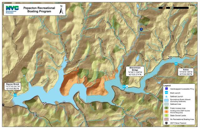
The Pepacton, built in 1954, was part of the Delaware system first approved in 1931 that included the Rondout, Neversink, and Cannonsville reservoirs. They augmented the earlier Ashokan and Schoharie reservoirs in the Catskills. These new reservoirs were to meet New York City’s water needs at least until 1990.
The story of the Pepacton Reservoir is revealed only in a small installation of several photo boards under a shelter at its northeastern corner. These modest boards provided the basics of the story and some excellent historic photos of the four hamlets that were inundated: Pepacton, Shavertown, Arena, and Union Grove. In all, 974 people were displaced, along with 36 businesses, 8 churches, 5 schools, 4 post offices, and 13 cemeteries, and a number of outlying farms.
 View of valley before inundation by Pepacton Reservoir.
From NYS interpretive exhibit ,
Margaretville, NY.
As part of the New York City water supply system, security is tight around the Pepacton Reservoir. There are no pull outs, no visitor centers. Fishing is allowed in the reservoir, but only by permit. There are only a few places to launch a boat.
I rode down route 1 from the north (Andes), and at the Shavertown Bridge I spotted a tent where food seemed to be for sale.

Yup, it was a full catered barbeque
I got the pulled pork w/pineapple, watermelon, 6 bean bake, and coleslaw, and ate at the water's edge.

Then a superb ride around the perimeter of the watershed on Rt 30, stopping at the dam.

The dam is 2,400 feet long, 200 feet high, and 1,800 feet thick at its base. The upstream side is concrete; the downstream side is a long, gently sloping earth embankment. The Reservoir is some 18 miles long, has a shore line of 50 miles, and a surface area of 6,400 acres. It drains a watershed of 370 square miles and holds 150 billion gallons of fresh water. A 26-mile long tunnel transports water eastward from the Pepacton Reservoir to the Rondout Reservoir, then through the Delaware Aqueduct towards New York City.

It needed repairs recently.

You feel on top of the world standing on the edge of the dam.
I typically stay only 10 minutes or so; any longer, and police will arrive and ask you what you're up to.


Route 30 borders this enormous man-made lake, twisting, sweeping turns one after another, a number of them resembling the Carousel Turns of the Road America, Mid-Ohio and Watkins Glen race circuits.
Mountains surround the reservoir.
The Pepacton, built in 1954, was part of the Delaware system first approved in 1931 that included the Rondout, Neversink, and Cannonsville reservoirs. They augmented the earlier Ashokan and Schoharie reservoirs in the Catskills. These new reservoirs were to meet New York City’s water needs at least until 1990.
The story of the Pepacton Reservoir is revealed only in a small installation of several photo boards under a shelter at its northeastern corner. These modest boards provided the basics of the story and some excellent historic photos of the four hamlets that were inundated: Pepacton, Shavertown, Arena, and Union Grove. In all, 974 people were displaced, along with 36 businesses, 8 churches, 5 schools, 4 post offices, and 13 cemeteries, and a number of outlying farms.
From NYS interpretive exhibit ,
Margaretville, NY.
As part of the New York City water supply system, security is tight around the Pepacton Reservoir. There are no pull outs, no visitor centers. Fishing is allowed in the reservoir, but only by permit. There are only a few places to launch a boat.
I rode down route 1 from the north (Andes), and at the Shavertown Bridge I spotted a tent where food seemed to be for sale.
Yup, it was a full catered barbeque
I got the pulled pork w/pineapple, watermelon, 6 bean bake, and coleslaw, and ate at the water's edge.
Then a superb ride around the perimeter of the watershed on Rt 30, stopping at the dam.
The dam is 2,400 feet long, 200 feet high, and 1,800 feet thick at its base. The upstream side is concrete; the downstream side is a long, gently sloping earth embankment. The Reservoir is some 18 miles long, has a shore line of 50 miles, and a surface area of 6,400 acres. It drains a watershed of 370 square miles and holds 150 billion gallons of fresh water. A 26-mile long tunnel transports water eastward from the Pepacton Reservoir to the Rondout Reservoir, then through the Delaware Aqueduct towards New York City.
It needed repairs recently.
You feel on top of the world standing on the edge of the dam.
I typically stay only 10 minutes or so; any longer, and police will arrive and ask you what you're up to.
WOW - what a beautiful spot! I’d like to ride there someday.
Yesterday I returned to the Catskill Mountains to ride the 4 hour loop from Mine Kill Park south to Pepacton Reservoir.

Route 30 borders this enormous man-made lake, twisting, sweeping turns one after another, a number of them resembling the Carousel Turns of the Road America, Mid-Ohio and Watkins Glen race circuits.
View attachment 172158Road America
Mountains surround the reservoir.
The Pepacton, built in 1954, was part of the Delaware system first approved in 1931 that included the Rondout, Neversink, and Cannonsville reservoirs. They augmented the earlier Ashokan and Schoharie reservoirs in the Catskills. These new reservoirs were to meet New York City’s water needs at least until 1990.
The story of the Pepacton Reservoir is revealed only in a small installation of several photo boards under a shelter at its northeastern corner. These modest boards provided the basics of the story and some excellent historic photos of the four hamlets that were inundated: Pepacton, Shavertown, Arena, and Union Grove. In all, 974 people were displaced, along with 36 businesses, 8 churches, 5 schools, 4 post offices, and 13 cemeteries, and a number of outlying farms.
View of valley before inundation by Pepacton Reservoir.
From NYS interpretive exhibit ,
Margaretville, NY.
As part of the New York City water supply system, security is tight around the Pepacton Reservoir. There are no pull outs, no visitor centers. Fishing is allowed in the reservoir, but only by permit. There are only a few places to launch a boat.
I rode down route 1 from the north (Andes), and at the Shavertown Bridge I spotted a tent where food seemed to be for sale.
View attachment 172159
Yup, it was a full catered barbeque
I got the pulled pork w/pineapple, watermelon, 6 bean bake, and coleslaw, and ate at the water's edge.
View attachment 172160
Then a superb ride around the perimeter of the watershed on Rt 30, stopping at the dam.

The dam is 2,400 feet long, 200 feet high, and 1,800 feet thick at its base. The upstream side is concrete; the downstream side is a long, gently sloping earth embankment. The Reservoir is some 18 miles long, has a shore line of 50 miles, and a surface area of 6,400 acres. It drains a watershed of 370 square miles and holds 150 billion gallons of fresh water. A 26-mile long tunnel transports water eastward from the Pepacton Reservoir to the Rondout Reservoir, then through the Delaware Aqueduct towards New York City.
It needed repairs recently.
You feel on top of the world standing on the edge of the dam.
I typically stay only 10 minutes or so; any longer, and police will arrive and ask you what you're up to.
View attachment 172161
View attachment 172162
View attachment 172163
Well done Jeff! Another well written travelogue. I so enjoy seeing another part of this world, the photos are great as usual and the back story on the reservoir system was very interesting. Such beautiful country!
By the way.....that BBQ looks killer!
Last edited:
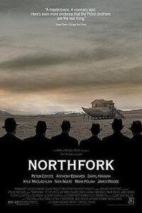
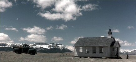
There is a spooky, interesting Nick Nolte / James Woods film called Northfork, which is about the men whose job it is to remove the last of the townsfolk who refuse to move when a reservoir is being built, and the water is about to rush in.


Attachments
I walked back and forth under the First St bridge many, many times getting from home near Van Buren and First to Dixon HS and back in 1958-1962.When I got back to town stopped and took this pick. There are 3 of these RR bridges in town. They are 1 block apart from each other. The Southern most one is 3 blocks North of my house. The tracks were across the street from me. Built in 1855 and used 130 years. All 3 are still in very good shape. I don't remember ever seeing any repairs done to them. I guess they were built well.
View attachment 172073
View attachment 172074
Ive only had the ST1100 since the end of June and I have more miles on it than I have with the XS650 since last Sept...Poor little sixfiddy isnt seeing much running time..Took them both out this a.m. but not too far as its really a sauna bath out there...Here we are happy together...

Both great looking bikes! 
Paint shaker vs. Sewing machine...
Hey, guyz.
Been awhile since posting.
In the spirit of this thread, I've been ridin' the Vegas on group rides with a clump of octogenarians.

Been posting my struggles in here...
https://www.thevog.net/threads/texican-gets-a-vegas.160031/
Been awhile since posting.
In the spirit of this thread, I've been ridin' the Vegas on group rides with a clump of octogenarians.
Been posting my struggles in here...
https://www.thevog.net/threads/texican-gets-a-vegas.160031/
Took the old 1976 XS650 on the longest ride that I've been on in ages -- maybe my longest single day ride ever. From Austin to Houston and back, a total of about 330 miles. It was only supposed to be half of that. The intention was to buy an El Camino (of sorts...) in Houston, load the bike up, and drive home to Austin. Unfortunately, the vehicle failed the test drive, but I'm still buying it, and now the seller is going to deliver it. Already a done deal.

So, here it is. This is a pretty rare model, Dodge's version of the El Camino, but as a subcompact, made from 1982 to 1984. Called the Dodge Rampage. But actually, this one is rarer still. In 1983 and 1984, Plymouth rebadged it as the Scamp. And this is the even rarer and more desirable 5 speed GT Prospector. Only 1380 GT models made. So there you have it, a 1984 Plymouth Scamp GT. Paid $1,800 for it, which is quite a deal.

Here's a Rampage with nice paint. These seem to have sort of a cult following.
The Scamp failed the test drive for a few reasons, some of which the owner figured and fixed after I left. The worst was that it overheated. That turned out to be a bad thermostat. Next, it was really hard to shift into first. This turned out to be piece of plastic floormat that was stuck in the newly installed new shift kit. Third was an obnoxiously loud exhaust. Some kind of turbo exhaust issue that should be easy to restore to the way it's supposed to be. And finally, the carb has idle issues. That may take a little looking into it. Otherwise, I'm pretty stoked!
So, here it is. This is a pretty rare model, Dodge's version of the El Camino, but as a subcompact, made from 1982 to 1984. Called the Dodge Rampage. But actually, this one is rarer still. In 1983 and 1984, Plymouth rebadged it as the Scamp. And this is the even rarer and more desirable 5 speed GT Prospector. Only 1380 GT models made. So there you have it, a 1984 Plymouth Scamp GT. Paid $1,800 for it, which is quite a deal.
Here's a Rampage with nice paint. These seem to have sort of a cult following.
The Scamp failed the test drive for a few reasons, some of which the owner figured and fixed after I left. The worst was that it overheated. That turned out to be a bad thermostat. Next, it was really hard to shift into first. This turned out to be piece of plastic floormat that was stuck in the newly installed new shift kit. Third was an obnoxiously loud exhaust. Some kind of turbo exhaust issue that should be easy to restore to the way it's supposed to be. And finally, the carb has idle issues. That may take a little looking into it. Otherwise, I'm pretty stoked!
Took the old 1976 XS650 on the longest ride that I've been on in ages -- maybe my longest single day ride ever. From Austin to Houston and back, a total of about 330 miles. It was only supposed to be half of that. The intention was to buy an El Camino (of sorts...) in Houston, load the bike up, and drive home to Austin. Unfortunately, the vehicle failed the test drive, but I'm still buying it, and now the seller is going to deliver it. Already a done deal.
View attachment 172462
So, here it is. This is a pretty rare model, Dodge's version of the El Camino, but as a subcompact, made from 1982 to 1984. Called the Dodge Rampage. But actually, this one is rarer still. In 1983 and 1984, Plymouth rebadged it as the Scamp. And this is the even rarer and more desirable 5 speed GT Prospector. Only 1380 GT models made. So there you have it, a 1984 Plymouth Scamp GT. Paid $1,800 for it, which is quite a deal.
View attachment 172464
Here's a Rampage with nice paint. These seem to have sort of a cult following.
The Scamp failed the test drive for a few reasons, some of which the owner figured and fixed after I left. The worst was that it overheated. That turned out to be a bad thermostat. Next, it was really hard to shift into first. This turned out to be piece of plastic floormat that was stuck in the newly installed new shift kit. Third was an obnoxiously loud exhaust. Some kind of turbo exhaust issue that should be easy to restore to the way it's supposed to be. And finally, the carb has idle issues. That may take a little looking into it. Otherwise, I'm pretty stoked!
Well, I thought I’d seen it all. But I’ve never seen that one! Cool little car! I hope you get it all sorted out and running nice. You sure won’t see another one coming at you in traffic!

Bed length would be almost all used up fitting the XS in there, eh?
Hey, guyz.
Been awhile since posting.
In the spirit of this thread, I've been ridin' the Vegas on group rides with a clump of octogenarians.
I hope I get to be one of those octogenarians riding a motorcycle. I'm taking steps to make it possible.
Yes indeedy. If you put an XS650 in an El Camino bed straight, like you're supposed to (not angled), you have to lower the tailgate, but at least both wheels are in the bed. With the Scamp, the rear wheel will be sitting on the lowered tailgate. Not sure how sketchy that will be, but I think it will be okay. Hope so. The whole reason I bought this was to get better gas mileage when hauling bikes. But, I gotta say, this thing is really growing on me, glad I bought it.Bed length would be almost all used up fitting the XS in there, eh?
Unfortunately I am still not on the XS but the bottom end is DONE. Been slacking on progress with the build because I'm out RIDING.
Took a lotta roads I didn't know today. Just rode all around til I was content. I'm gonna love having a little more power. A 300 is kinda getting boring! As boring as a motorcycle can get that is.

Took a lotta roads I didn't know today. Just rode all around til I was content. I'm gonna love having a little more power. A 300 is kinda getting boring! As boring as a motorcycle can get that is.
Haven't ridden much this Summer between the freakin' heat and other obligations plus I just plumb ran out of places I haven't ridden 50 times. Finally caught a day when I had nothing better to do and the weather cooperated.
Solved the "been there, done that" conundrum by heading to my older daughter's new digs to check them out. About 130 miles one way. Took mostly back roads on the way down and then hit the Interstate on the way home.
I normally try to avoid the "I" as boring, but it was kind of fun for a change. 80 miles from Augusta to Bangor running between 70 and 85 (and occasionally a tad more... ) all the way. It's 20-ish miles longer that way, but MUCH faster. Don't often find the need to use 6th gear on the FJ, but that puts the motor right in it's sweet spot (4500-5000 RPM) at interstate cruising speed.
Didn't tell her I was coming. She moved to a group home for my grandson who is profoundly autistic. She has her own apartment and Shaun has his, along with 24/7 supervision/assistance. Gives her a break and is a start on transitioning him from complete dependence on his Mom. He's 19.
The looks from the crew when I pulled up on the bike were priceless. They had absolutely no clue who it was even after I took my helmet off.
Solved the "been there, done that" conundrum by heading to my older daughter's new digs to check them out. About 130 miles one way. Took mostly back roads on the way down and then hit the Interstate on the way home.
I normally try to avoid the "I" as boring, but it was kind of fun for a change. 80 miles from Augusta to Bangor running between 70 and 85 (and occasionally a tad more...
) all the way. It's 20-ish miles longer that way, but MUCH faster. Don't often find the need to use 6th gear on the FJ, but that puts the motor right in it's sweet spot (4500-5000 RPM) at interstate cruising speed.Didn't tell her I was coming. She moved to a group home for my grandson who is profoundly autistic. She has her own apartment and Shaun has his, along with 24/7 supervision/assistance. Gives her a break and is a start on transitioning him from complete dependence on his Mom. He's 19.
The looks from the crew when I pulled up on the bike were priceless. They had absolutely no clue who it was even after I took my helmet off.